Sight beside the loop
The Nho Quế River flows below Mã Pí Lèng Pass, between Đồng Văn and Mèo Vạc, around Km170 of the Loop. Admire it from the pass, then head down for a boat trip through Tu Sản Canyon — a highlight of the whole route.
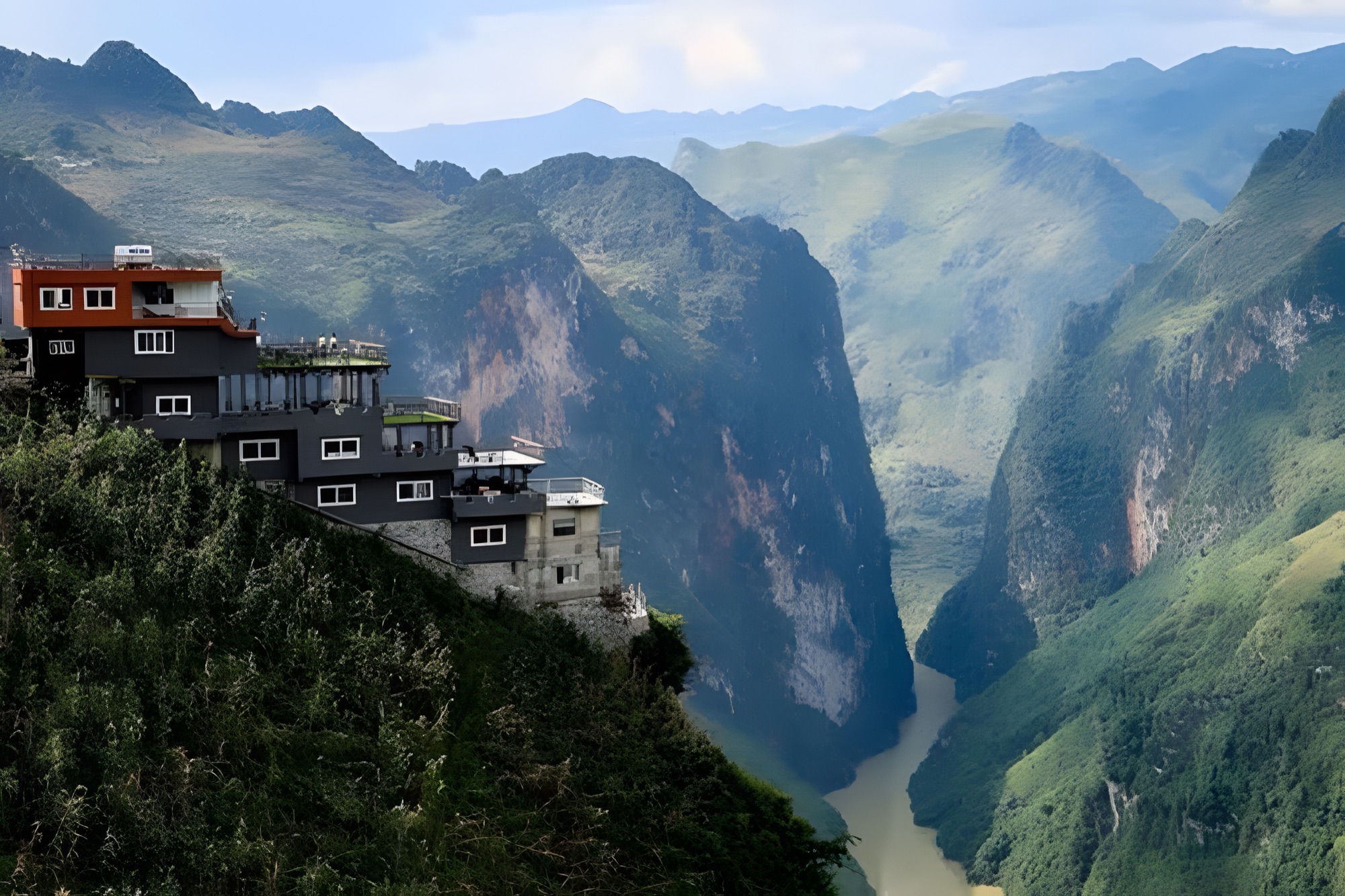
Look down from Mã Pí Lèng Pass and everyone stops at the same sight: a ribbon of jade-green water winding along the bottom of a deep gorge, squeezed between two sheer walls of rock. This is the Nho Quế River and Tu Sản Canyon — a landmark between Đồng Văn and Mèo Vạc, around Km170 of the Loop, and an image that has almost become the symbol of Hà Giang.
The Nho Quế rises in China, enters Vietnam in the far north and cuts across the Đồng Văn karst plateau. Below Mã Pí Lèng, the river has carved Tu Sản Canyon, with rock walls hundreds of metres high on both sides, which many people consider one of the deepest and most spectacular canyons in Southeast Asia. The jade colour of the water, deeper or paler with the seasons and the sunlight, makes the river look like a silk ribbon dropped among the grey stone mountains.
Getting down to the river
Most travellers only see the Nho Quế from the pass. But if you have time, set aside an extra leg to go right down to the riverbed. It is a side trip off the Đồng Văn – Mèo Vạc road over Mã Pí Lèng, following a small road along the mountainside, through villages and down to the boat area at the bottom of the canyon.
- Ask the way: there are several ways down and road conditions change with the seasons, so ask locals, your homestay or an easy rider about the road down to the boat pier before you set off.
- Gradient: the road is narrow and very steep, with many hairpin bends and sections barely wide enough for one vehicle; the surface can be gravelly, or slippery after rain.
- Riding yourself: only ride down on your own if you are used to mountain passes. Use a low gear downhill, brake evenly with both wheels and never coast; check your brakes before you go. On the climb back, keep the throttle steady and don't stop mid-slope.
- Easy rider: if you're not confident, let an easy rider or a local take you — safer, and you can enjoy the scenery.
- Time: counting the ride down, the boat trip and the ride back up, allow roughly half a day. Don't try to go down late in the afternoon or while it is raining.
Boat trip on the Nho Quế River
From the river itself, Tu Sản Canyon looks completely different. The boat glides slowly between two sheer rock walls, so high you have to tilt your head back to see the top, while the calm jade water reflects the mountains. The engine echoes off the cliffs, and now and then you spot goats on the slopes or small corn plots clinging to cracks in the rock. The trip usually lasts around one to two hours, depending on the route.
- Life jackets: wear one for the whole trip, even if you can swim.
- Go when the water is calm: ask the boatman about the water level; only go when the river is calm and the sky is clear.
- Rainy season: after heavy rain the river can rise quickly, run fast and turn muddy; boat trips may be suspended. Follow local advice and don't insist on going.
- Belongings: bring a dry bag for your phone and camera; stay seated and don't stand up for photos while the boat is moving.
Viewpoints & photo spots
- Mã Pí Lèng Panorama: a viewpoint on the pass overlooking Tu Sản Canyon and the Nho Quế River — the most familiar angle, handy for a rest and a drink.
- Stops along Mã Pí Lèng Pass: the pass has plenty of wide spots to pull over and look straight down at the green river; park close to the mountain wall, never on a bend.
- The "death rock": a rock ledge jutting out over the abyss, famous on social media. There is no railing, the wind is strong and the rock can be slippery — stay behind the edge, don't climb out onto the ledge, and don't jump or pose dangerously just for a photo.
- River bends: the curves of the river at the foot of the mountains form jade-green arcs seen from above — best in morning sunshine.
- Villages on the slopes: ethnic minority villages sit on the mountainside along the road down to the river, with rammed-earth houses, terraced corn fields and views into the canyon. Ask before photographing people.
Best time & tips
- Dry season (roughly autumn to spring): the river is clear and at its most jade-green, skies are often clear and visibility is good.
- Rainy season (summer): after heavy rain the water turns muddy brown, the road down is slippery and there is a risk of local landslides.
- Best light: morning, when the sun reaches into the canyon and lights up the water; in the afternoon part of the canyon falls into the mountains' shadow.
Tips:
- Fill up with fuel in Đồng Văn or Mèo Vạc before turning off towards the river.
- Bring water, a windbreaker and shoes with good grip; it's windy and cold on the pass, but the sun can be fierce down by the river.
- Don't fly a drone in strong wind, and respect restricted areas, especially near the border.
- Check the weather; if there has been heavy rain in the previous days, ask locals about the road and the river.
See Hà Giang from the sky
Having seen Tu Sản Canyon from the bottom, you'll want to see the plateau from above. Try paragliding or paramotoring at the Quản Bạ flying site, or paragliding over the Đồng Văn karst plateau — just book ahead to hold your spot.
Next stop: Mèo Vạc · Previous stop: Mã Pí Lèng Pass · Read more: boat trip on the Nho Quế River and Tu Sản Canyon